
Navigation by Skylight Polarization via Rayleigh Model Optimization on a Road Vehicle
Ben Potter, Eslam Mounier, Aboelmagd Noureldin, Yahia Antar, Muhammad Alam · N/A · 2026
Framework
N/A
License
N/A
Stars
N/A
Summary
Reliable absolute heading estimation is critical for road-vehicle navigation, particularly when magnetic, inertial, or GNSS-based references are degraded.
Abstract Summary
Key Points
- Reliable absolute heading estimation is critical for road-vehicle navigation, particularly when magnetic, inertial, or GNSS-based references are degraded.
- This paper presents a skylight polarization navigation method that estimates vehicle heading by globally optimizing a Rayleigh sky model against measurements from a division-of-focal-plane polarimetric camera.
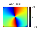
- The proposed framework combines a pinhole camera model, a single-scattering Rayleigh polarization model, and a solar position algorithm to synthesize the expected full image angle of polarization distribution for candidate vehicle states.
- A degree of polarization weighted root mean square error objective function compares measured and simulated polarization patterns, allowing the estimator to use all available sky information while attenuating low confidence pixels caused by clouds, buildings, foliage, and other depolarizing occlusions.
- Experimental evaluation is performed using three urban road vehicle trajectories collected with a roof mounted polarimetric camera and a high precision dual-antenna GNSS/INS reference system.
Theory of Skylight Polarization for Navigation
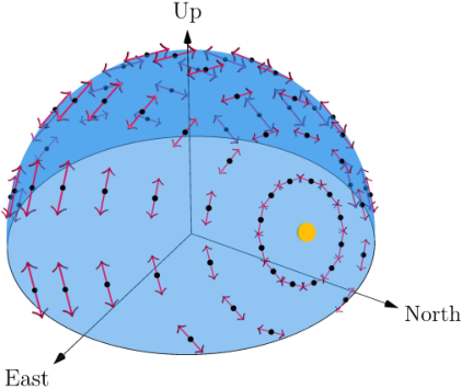
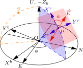
The horizontal coordinate system, denoted the $n$-frame, has axes $E$, $N$, and $U$, with an origin located at the observer, $O$. Following the convention for horizontal coordinate systems, its axes are aligned with the cardinal east and north directions with the $U$ axis pointing upward. All other coordinate systems are placed relative to the $n$-frame.
The camera body coordinate system, denoted the $b$-frame, has axes $X^{b}$, $Y^{b}$, and $Z^{b}$, with an origin located at the observer, $O$.
Model Optimization
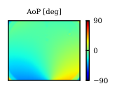
We propose a method of absolute heading estimation from skylight polarization based on optimization of the Rayleigh sky model. Our method combines a pinhole camera model with the Rayleigh model to simulate images of the skylight polarization pattern given the state (i.e., position, time, and orientation) of a virtual camera.
We define an objective function that encodes the proximity of an estimated state of a virtual camera to the true state of a given measured image using this simulation. Fig.
Instrumentation and Dataset
Our dataset is constructed using a modified consumer road vehicle, shown in Fig. 7 . The modifications to the road vehicle are made to support advanced multi-sensor navigation research. The on-board reference system has been applied to previous navigation research by Araujo et al. [ 42 ] .
The reference navigation solution is generated using a NovAtel PwrPak7 integrated system, configured with dual GNSS antennas and a high-performance NovAtel IMU-µIMU-IC.
Results
The performance of the model optimization method is summarized in Table I . We include the performance of Lu’s method [ 24 ] and Wang’s method [ 30 ] for comparison. We provide the RMS, P95, and maximum absolute error as measures of algorithm performance. The P95 error represents the lowest error that contains $95\text{\,}\mathrm{\%}$ of all estimates.
Following, we explain our choices for the model optimization algorithm’s hyperparameters.
Sources and Demonstrations
Figures are reproduced from Potter et al. See the full paper for experimental details and the project page, when the paper links one, for demonstrations and videos.
Related Papers

Aim Short to Reach Far: Your Frozen World Model Can Plan Better Than You Think
Xvyuan Liu, Jianjie Fang, Chen Gao et al.
Planners built on visual world models commonly score each predicted outcome by its distance to the encoded goal image. We show that this target can limit control even with exact dynamics and globally optimal short-horizon search: reaching a goal may require actions that initially move away from it.
Beyond Episodic Evaluation: Memory Architectural Bottlenecks in Sequential Embodied Question Answering
Zikui Cai, Kaushal Janga, Tan Dat Dao et al.
Embodied question answering (EQA) is traditionally evaluated under an episodic formulation, where agents solve each task independently and reset internal state between episodes.
EditWM: Event-Decomposed World Modeling with Incremental Correction for End-to-End Autonomous Driving
Junjie Yang, Qingwei Zeng, Youyou Li et al.
World models support autonomous driving by predicting the scene evolution associated with candidate trajectories. Driving dynamics differ in predictability, motivating a distinction between regular evolution and event-induced deviations that call for selective correction.
Embodied Scene Rearrangement Planning
Canzhi Chen, Zan Wang, Siqi Zhu et al.
This paper introduces Embodied Scene Rearrangement Planning (ESRP), a novel task requiring embodied agents to rearrange furniture in 3D scenes to match a target configuration using only egocentric observations and a top-down target layout.